DMD Navigation FAQ
A compilation of frequently asked questions about our hardware and software.
DMD2 App (11)
Map updates are pushed ever two months. However, to ensure no loss of navigation ability while using the system, there is no automatic map update in DMD2. You will be notified of map updates by the Map Layer icon on the “Map View” page displaying, in green, the number of available updates as a number. To trigger the update, you must manually enter the “Map Layer”, go to download maps, the respective region and selecting and updating each individual map.
A data connection is required for the map update.
Once you have started a map update, the map being updates is no longer available until the update is complete.
There are two common causes for map downloads:
The WiFi connection is slow and/or unstable. In this situation it is recommended to priorities which maps to download or update and do these one at a time. Typically the download will complete but it can take a long time depending on the quality of the connection.
Insufficient space or memory on your device. In this situation delete maps and/or GPX Tracks/Routes which are no longer needed.
DMD2 includes both place searching using the online Google Places API and place search using the offline map database!
The place search dialog include the following options:
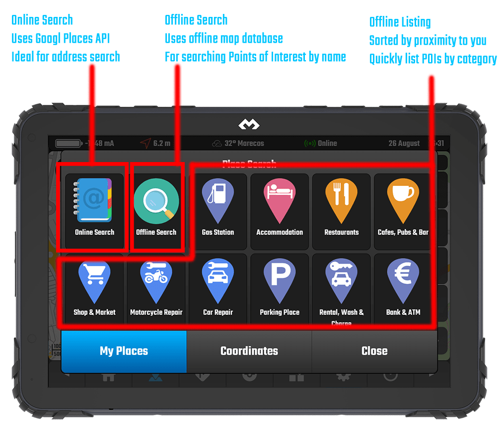
If you are just looking for the closest POI of a specific category, then just tap on the icon for that category, the offline category listing will display a list of the closest places matching that category. Notice that you can scroll the categories and there is one for Town/City/Village too.
If you are searching for a specific POI name then use the Offline search, it should find what you are looking for.
If you are searching for a full address, with street name, number and postal code, then you need to be online and use the Online Search – this uses the full power of Google Places (the best place API) and can find based on address or name.
To export a recording (GPX file) you simply need to go to GPX Recorder > Recordings > select the recording from the list and press Share.
When you share the file, Android will show you all the installed apps to where you can share it, usually you would select something like Google Drive to store it online, but you can also select your email app if you want to send it by email to someone or even select an instant messaging app if you are sharing it in a chat.
The Track Progress on the left side of the map view shows automatically (if enabled) if you are on top, or close to a GPX Track Line.
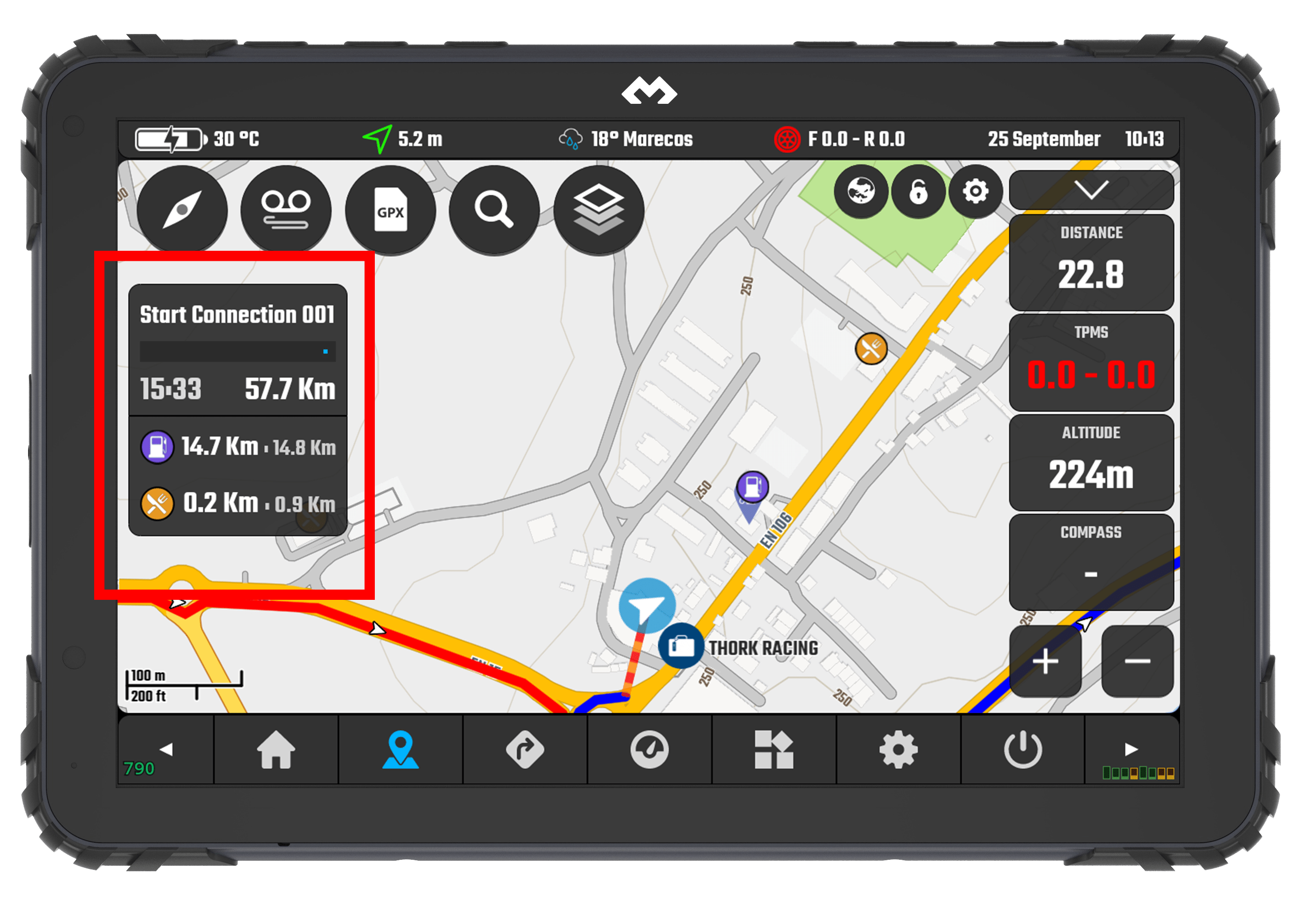
The information available for this box is:
Track Progress -> Track name / ETA / Distance to Finish
Distance to POIs -> User selectable (up to 3) POI categories to show along the track line
Next Waypoint -> Next Waypoint Name / Distance -> If there is any on the GPX file and close to the current track
—
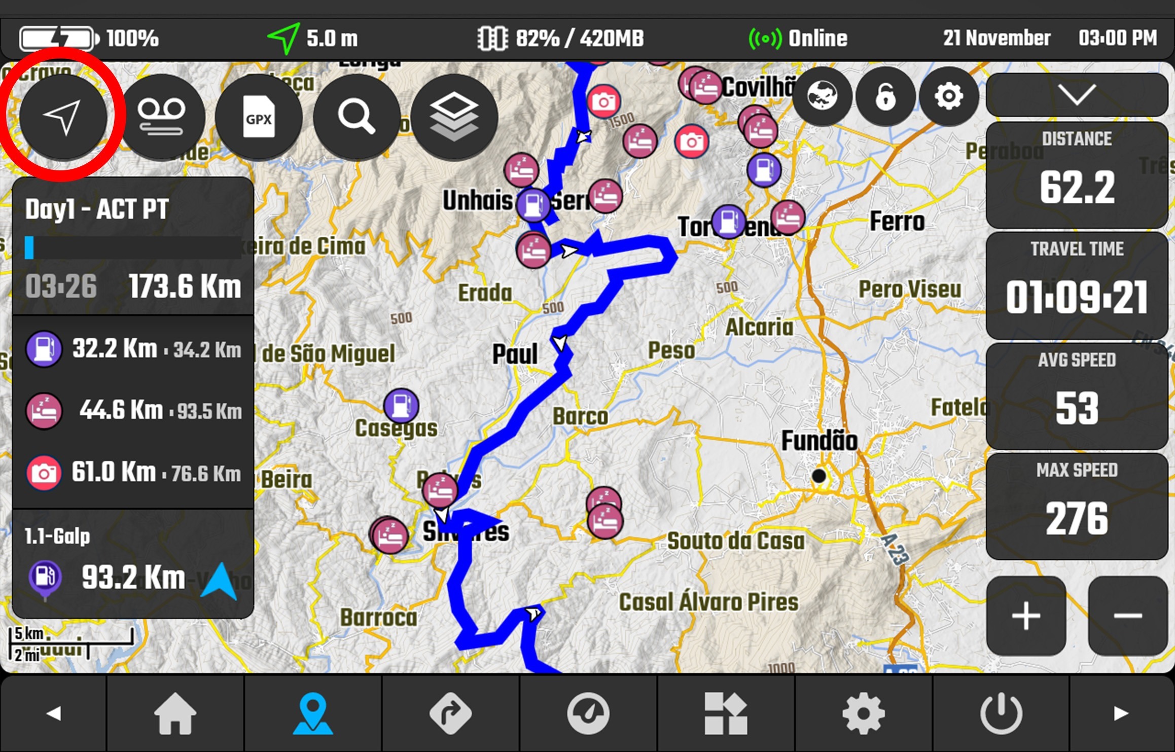
If you are on top of a track line and you cannot see this box check the following:
- Make sure it is actually a TRACK and not a ROUTE -> Read this to understand the difference
- Make sure “Enable track progress info box” is enabled in map settings:
—
To enable the POIs along the track:
- Click “GPX” button in map view
- Click “Settings” in the bottom of the dialog
- Set it up under “Auto Find POIs”
DMD2 dialogs are made to be easy to use while riding and with gloves, they usually are big and take most of the screen space.
We get asked often how to view the locations / tracks / waypoints from the listings while using the dialogs, for this we already have a function that makes the dialog take half space in the screen.
Tap the “minimise” button on the top right corner of the dialog:
Also, if you want the last position to be remembers, to make the map not move back to your current location, then disable follow location before using the dialog:
Ensure the “Arrow” on the top left of the Map View screen looks like a compass needle or a filled in white arrow.
Compass Mode – Map follows location and rotates to face travel direction.
Filled White Arrow – Map follows location but will not rotate, top is north.
Notice: Ensure you are travelling at more than 4 kph or 2.5 mph.
The only follow mode where the map will NOT MOVE – follow mode disabled – is when the button shows an empty arrow icon, use any other mode for the map to track your location:

Users often confuse saving a location with a “waypoint”, in DMD2 a user location can be stored and made visible on the map. This should not be confused with adding a waypoint to an ongoing GPX recording which will be added to the GPX file once the recording is finished and the file saved.
The way you save location and view them on the map is through the PLACE SEARCH dialog (the magnifying glass button in the map view).
Steps to save a location:
- Tap and hold anywhere on the map to start the “Map Long Press Actions” dialog
- Now tap on “Save Location” button
- Fill in your location information (icon, name, description)
- You can choose to enable the “Keep visible on map” toggle -> this will make the location icon always visible on the map
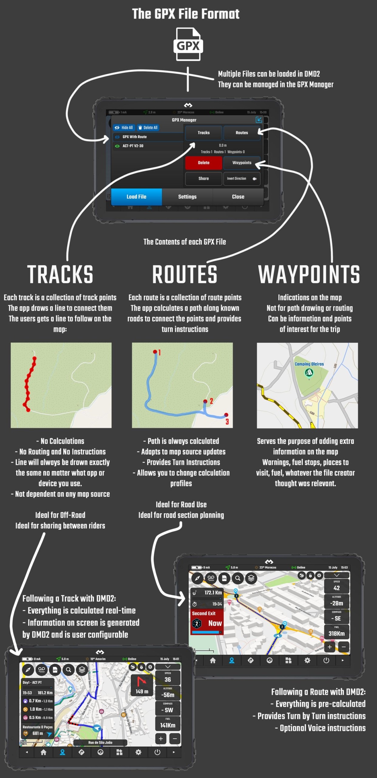
There is a lot of confusion about GPX files. You should understand that the content of a GPX file can be:
– TRACKS – Point by point drawn on the map, no turn by turn instructions, you follow the line, there is no calculation done, the track stays the exact same no matter where you load it
– ROUTES – Points with the places you want to go through, the app will calculate a route to take through all those points, it has turn by turn instructions and you can change the calculation profile
– WAYPOINTS – Pins / Indications on the map – Informative icons on the map with alerts, places to stop, fuel, whatever you want