-
AuthorPosts
-
3 August 2024 at 1:50 am #8331
 SteveParticipant
Hi Guys,
It would be great if there was a “look ahead feature” of a new track’s elevation profile, whilst riding, so you can see steep inclines/declines before you commit to them. And also in the GPX Editor for planning.
Cheers,
Steve
-
This topic was modified 5 months, 3 weeks ago by
 Steve.
3 August 2024 at 1:53 am #8332 MonteParticipant
Hmmmm. Or maybe just look up at the road/trail ahead. I mean, how much info do we really need, beyond basic guidance. I really think that providing way too much detail makes it too easy to ride the GPS instead of riding the real world out front. But hey, just my opinion.
3 August 2024 at 2:03 am #8334 SteveParticipant
Yeah I take your point SC, however it can be impossible to see around hilly corners, and I would prefer to have a premium navigation device which would reduce me injuring myself in a remote area.
3 August 2024 at 2:10 am #8335 MonteParticipant
Sure. Thing is, no nav device can truly provide the detailed info needed to navigate technical terrain. How would you ride a blind corner differently if you knew there was an incline? It can’t tell you what kind of surface or traction level there is. It can’t tell you if it is smooth, rutted, wet, dry, etc. You have to ride what you can see. No device can make those split second adjustments for you in real time, and looking down at the screen just increases the risk you will not see and adapt to what’s in front of you. ‘Riding the GPS’ is dangerous, and entirely misses the point of riding a motorcycle.
3 August 2024 at 11:54 pm #8338 iwillgosecondParticipant
“slope angle” is a very powerful feature for difficult remote riding and is one of the most powerful features on another app. Dev is apparently implementing this and hopefully it will use coloring within the track line. …and this is something that is most useful when planning what your up against especially when you are losing light. Not something that is pertinent directly ahead of you.
-
This reply was modified 5 months, 2 weeks ago by
 iwillgosecond.
-
This reply was modified 5 months, 2 weeks ago by
 iwillgosecond.
4 August 2024 at 2:54 am #8341 SteveParticipant
That sounds like a great idea, thanks Iwill
28 December 2024 at 10:34 pm #25838 DaiParticipant
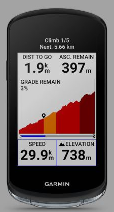
My Garmin Edge bicycle device has a feature called Climb Pro, which is extremely useful for anticipating the elevation profile ahead on the route, especially if you can’t see the climb because it’s around the bend. I have mounted my Edge to my bars to see if it will work on a motorbike, and I will try it out once the snow clears. Perhaps something similar could be a widget on the DMD2 home screen.

-
This topic was modified 5 months, 3 weeks ago by
-
AuthorPosts
- You must be logged in to reply to this topic.

