-
AuthorPosts
-
10 July 2024 at 9:39 pm #7620
 Bill McPoyleParticipant
Can we save bulk GPX, Waypoint, etc in folders that can be toggled on/off? For example, sometimes I visit state forests and private parks that have mapped out trails/routes that are require me to individually trigger each waypoint/gpx (hill climb, scenic view, water crossing, etc).
I have this in OnX and was using it before getting my hands on a T865 and really liked that feature. I may be overlooking this so correct me if so.
11 July 2024 at 11:47 am #7624 João PereiraKeymaster
A GPX file can include Tracks / Routes / Waypoints. That is how a GPX file is. I cannot understand the concept of folders in regards to a GPX file.
You can have multiple GPX files loaded in the app and hide / show each file or each track or each waypoint.You can also save and show or hide your own Locations, and this would be the only non-GPX thing that you can load on the map.
What are you riding exactly? A pre-planned GPX file? If so, additionally to the information on the GPX file you can also load Points of Interest for the categories you want:
– GPX -> Settings -> Auto POIBesides this you can also tweak the map to show some types of POI icons at higher zoom levels:
– MAP LAYERS -> POI Icon HighlightDMD2 Project Manager & Lead Developer
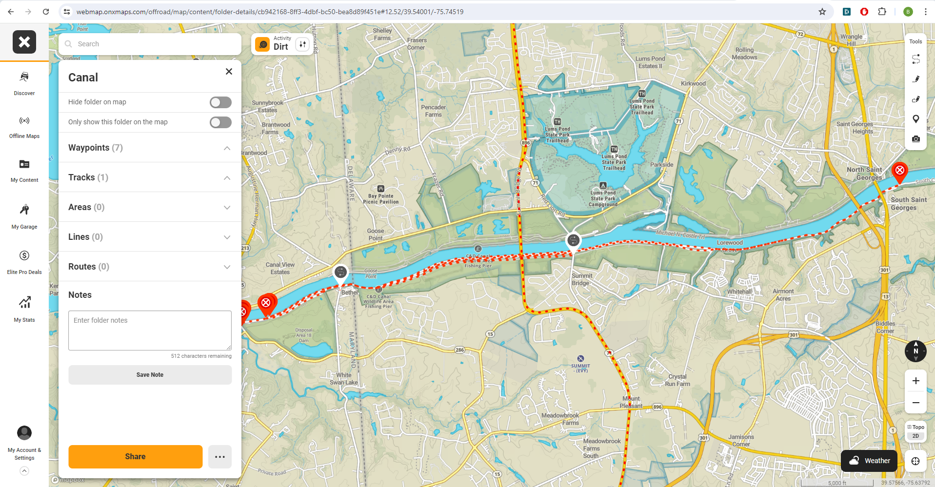
Buy Me a Coffee11 July 2024 at 2:35 pm #7629Bill McPoyleParticipantI have pre-planned routes that I have received from others and some from tracking myself going around. I have added some markers on map for hill climbs, water crossings, wash outs, tech inspection, service, reserved lodging, gates, entrances, etc and have to individually select each item on and off depending on where I plan on riding. Example could be Wharton State Forest, Sandblast Rally, McCreary Gravel Rally, Famous Reading Outdoors. Each is a unique event/place that I could save waypoints, gpx routes, locations as a bundle and hide or show all as one without fear of missing things.
Below is a small example of a local multi-tier canal that I noted gates, wash outs, and entrances from the main roads. 7 waypoints/markers and 1 track on/off with one button press.
 12 July 2024 at 4:30 pm #7688João PereiraKeymaster
I have pre-planned routes that I have received from others and some from tracking myself going around. I have added some markers on map for hill climbs, water crossings, wash outs, tech inspection, service, reserved lodging, gates, entrances, etc and have to individually select each item on and off depending on where I plan on riding. Example could be Wharton State Forest, Sandblast Rally, McCreary Gravel Rally, Famous Reading Outdoors. Each is a unique event/place that I could save waypoints, gpx routes, locations as a bundle and hide or show all as one without fear of missing things. Below is a small example of a local multi-tier canal that I noted gates, wash outs, and entrances from the main roads. 7 waypoints/markers and 1 track on/off with one button press.
But to me that just sounds like a folder is one “GPX FILE”.
That is very similar to what i do. I for example have one GPX file per mountain. Each GPX file contains:
– Main Tracks
– Secondary Tracks
– Connection Tracks
– Waypoints for information and Waypoints that are used like POIs (example: Restaurants)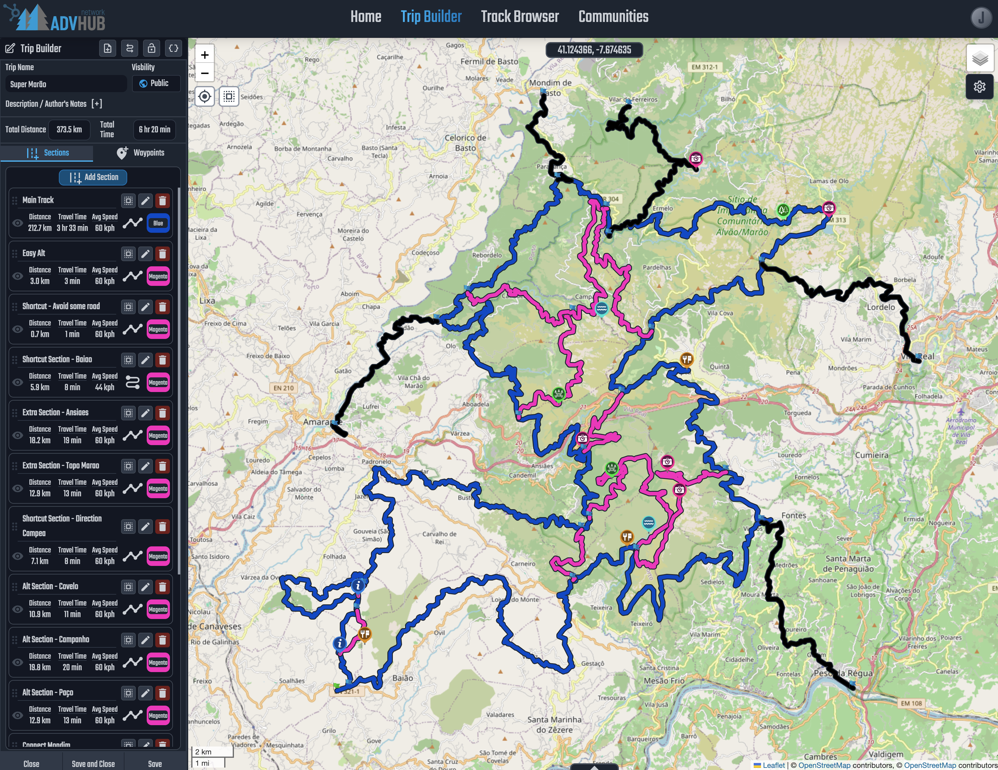
This is one single file.
I load them in DMD2 GPX Manager and i hide or show them according to where i am.I think it all comes down to “Workflow” and i try to keep eveything as close as possible to a multi-platform and multi-app solution, a standard model like the GPX file.
Onx “folder” method is not a standard, its not a multi-app solution, its a specific solution that will only work with Onx, i try to stay away from that specially when a standard solution already exists.For example, you say:
“Can we save bulk GPX, Waypoint, etc in folders that can be toggled on/off?”
Basically this would work like:_ Mount X
| _ _ Tracks
| _ _ _ Main Tracks
| _ _ _ Alternative Tracks
| _ _ _ Connection Tracks
| _ _ Routes
| _ _ Wpts – Information
| _ _ _ Warnings
| _ _ _ No Go
| _ _ Wpts – Camping
| _ _ Wpts – WaterThen inside each folder you would drop a GPX file containing either corresponding tracks or the corresponding Wpts, and then you toogle On/Off the content of the folder correct?
Is this the type of system you are looking for?
-
This reply was modified 8 months, 4 weeks ago by
 João Pereira.
DMD2 Project Manager & Lead Developer
Buy Me a Coffee12 July 2024 at 5:01 pm #7690Bill McPoyleParticipantThat is along the lines yes. Maybe even simplified without subfolders. Just a main folder to store routes, waypoints for an event or a day. Like if I were doing a multi-day rally I could have “Day 1”, “Day 2”, etc.
I am long-holding on screen to set markers on map with my T865 on DMD2. Is there an easier program to use and do this? I tried the online DMD2 route builder on phone to put several waypoints in one file to share with others doing events but I wasn’t allowed export without a route. Route will be provided by organizers day prior to start an I just wanted, for this event, bubbles on map to bring it to attention clearly where I must stop to check-in.
I found setting markers in OnX, exporting, renaming each file “checkpoint 1, 2,… etc”, moving into GoogleDrive, opening in DMD2 was an easy method.
I see the screencapture you sent and that looks intriguing. What gpx editor would you recommend or how can I make just waypoints and name them, in bulk, then import them as a single file?
12 July 2024 at 5:02 pm #7691João PereiraKeymasterThat is along the lines yes. Maybe even simplified without subfolders. Just a main folder to store routes, waypoints for an event or a day. Like if I were doing a multi-day rally I could have “Day 1”, “Day 2”, etc. I am long-holding on screen to set markers on map with my T865 on DMD2. Is there an easier program to use and do this? I tried the online DMD2 route builder on phone to put several waypoints in one file to share with others doing events but I wasn’t allowed export without a route. Route will be provided by organizers day prior to start an I just wanted, for this event, bubbles on map to bring it to attention clearly where I must stop to check-in. I found setting markers in OnX, exporting, renaming each file “checkpoint 1, 2,… etc”, moving into GoogleDrive, opening in DMD2 was an easy method. I see the screencapture you sent and that looks intriguing. What gpx editor would you recommend or how can I make just waypoints and name them, in bulk, then import them as a single file?
The picture i sent is the Web Router we are developing, fully original solution planner with multi track, multi profile per track.
Work in progress and not released yet.DMD2 Project Manager & Lead Developer
Buy Me a Coffee12 July 2024 at 5:13 pm #7692Bill McPoyleParticipantCan I put several waypoints together in a single gpx file without a route being built between them? Any current online solution I should use?
12 July 2024 at 10:09 pm #7695 ThorParticipant
At the moment I think this is possible in gpx.studio
Thor
- At jeg skal rygge? Skakkeryggejeg!15 July 2024 at 9:58 am #7723João PereiraKeymasterCan I put several waypoints together in a single gpx file without a route being built between them? Any current online solution I should use?
Lets be DARK LORDS INQUISITOR OVERLORDS about GPX terms. We need to stop using the wrong GPX terms!
There is no other alternative! A waypoint is NEVER routed. A Waypoint is a pin on the map, it serves no other purpose!!
A GPX can have tracks with track points that are connected to draw lines on the map -> no routing
A GPX can have routes with route points that will be connected using turn by turn calculation -> routing
A GPX can have waypoints which are just markers with information.DMD2 Project Manager & Lead Developer
Buy Me a Coffee15 July 2024 at 12:33 pm #7726Bill McPoyleParticipantThe GPX Editor on the website seems to only plot out routes. These are either snap to road or straight line. Can I piece together just waypoints on your editor?
-
This reply was modified 8 months, 4 weeks ago by
-
AuthorPosts
- You must be logged in to reply to this topic.